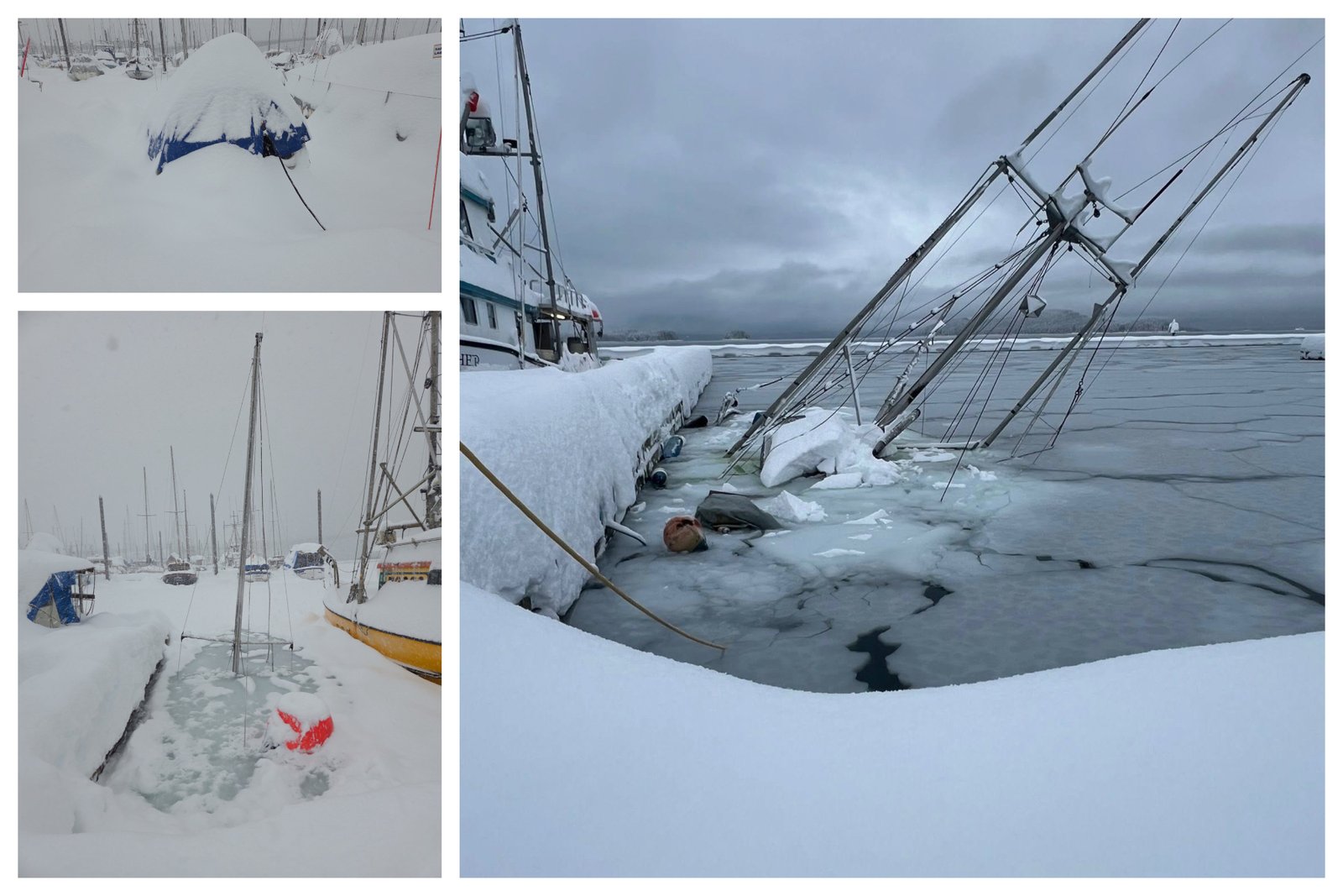
Vessel in distress and sinking at Juneau’s harbor due to heavy snow load on decks and docks. Credit: Juneau Harbors photo via Facebook, December 31, 2025.
NOAA forecasts continued snow and rough seas as harbor impacts and travel challenges persist.
By Gina Hill | Alaska Headline Living | January 2026
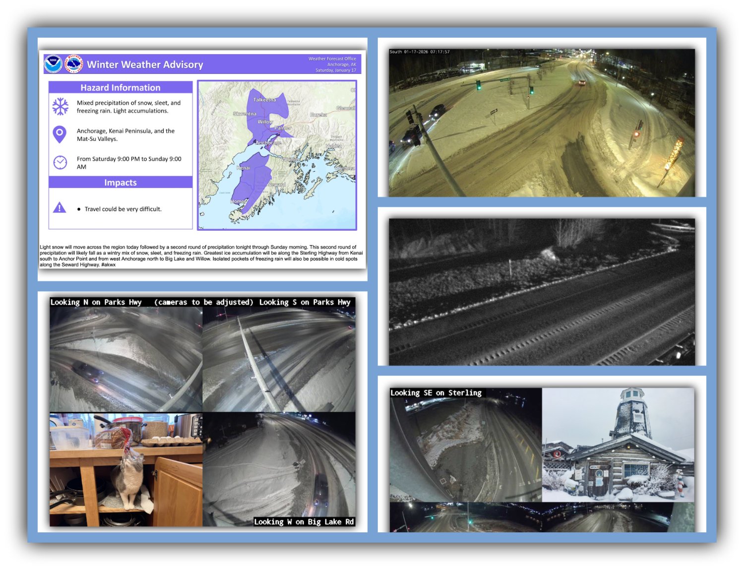
Juneau and much of Southeast Alaska remain locked in a stubborn winter pattern, with snow and cold continuing through early next week. The National Weather Service forecast shows little relief in the short term, with multiple rounds of snow expected and the potential for heavy snowfall as the week begins. Temperatures stay cold through Monday before slowly edging upward later in the week, raising the possibility of a rain and snow mix.
Marine conditions remain hazardous as well. NOAA’s marine forecast continues to highlight rough seas, strong winds, and freezing spray in the inner channels, keeping conditions risky for vessels and adding pressure on harbor operations already stretched thin by snow loading and ongoing response efforts.
This prolonged pattern follows an exceptionally snowy December, with persistent cold air keeping precipitation locked in as snow instead of rain. Heavy, wet snow continues to pile onto docks, roofs, and vessel decks, creating structural stress across the waterfront.
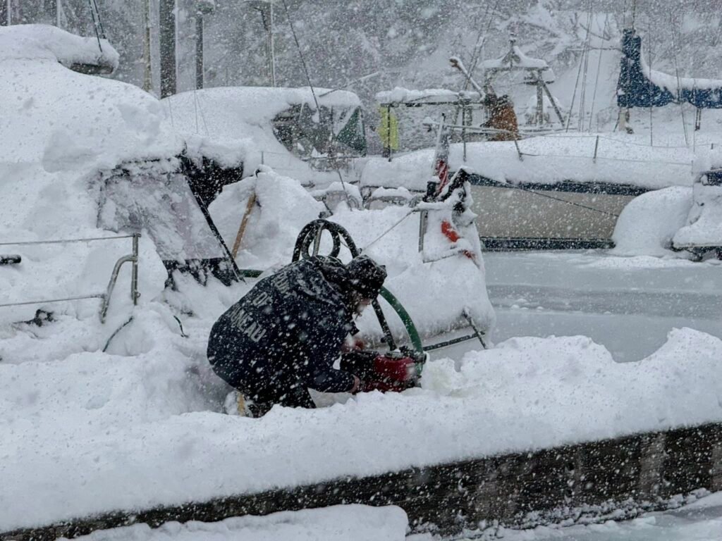
That snow load has already taken a toll. City and Borough of Juneau Docks and Harbors crews are working around the clock to dewater and stabilize boats as multiple large vessels have sunk in local harbors. The impacts ripple outward, affecting marine traffic, vessel owners, and the businesses that depend on reliable harbor access. At the same time, city crews face rising snow removal costs and emergency response demands, while road conditions and tighter airport operations slow travel and freight. For many residents and businesses, weather-driven delays and schedule changes have become part of daily life.
Detailed Forecast
Snow remains the main story for Juneau through midweek, with heavier snowfall possible early before temperatures warm enough to introduce a rain and snow mix later in the week. NWS
| Day | Forecast | High | Low | Wind |
|---|---|---|---|---|
| Today | 40% chance of snow showers after noon, cloudy | Near 20 | — | East 5 to 10 mph |
| Tonight | 50% chance of snow showers, cloudy | — | Around 10 | East 5 to 10 mph |
| Saturday | 20% chance of snow showers before 9am, mostly cloudy | Near 13 | — | Northeast 10 to 15 mph |
| Saturday Night | Partly cloudy | — | Around 9 | Northeast 10 to 15 mph |
| Sunday | 30% chance of snow after 3pm, mostly sunny | Near 18 | — | Northeast around 10 mph |
| Sunday Night | Snow mainly after 9pm | — | Around 13 | — |
| Monday | Snow, heavy at times | Near 21 | — | — |
| Monday Night | Snow, heavy at times, cloudy | — | Around 19 | — |
| Tuesday | Snow, cloudy | Near 30 | — | — |
| Tuesday Night | Snow, cloudy | — | Around 25 | — |
| Wednesday | Snow, cloudy | Near 30 | — | — |
| Wednesday Night | Rain and snow, cloudy | — | Around 25 | — |
| Thursday | Rain and snow likely, cloudy | Near 37 | — | — |
The National Weather Service urges residents, mariners, and businesses to stay alert as this extended winter stretch continues. Monitoring forecasts and marine advisories on Weather.gov remains key as Juneau navigates more snow, rough seas, and the ongoing impacts of a winter that is not ready to loosen its grip.