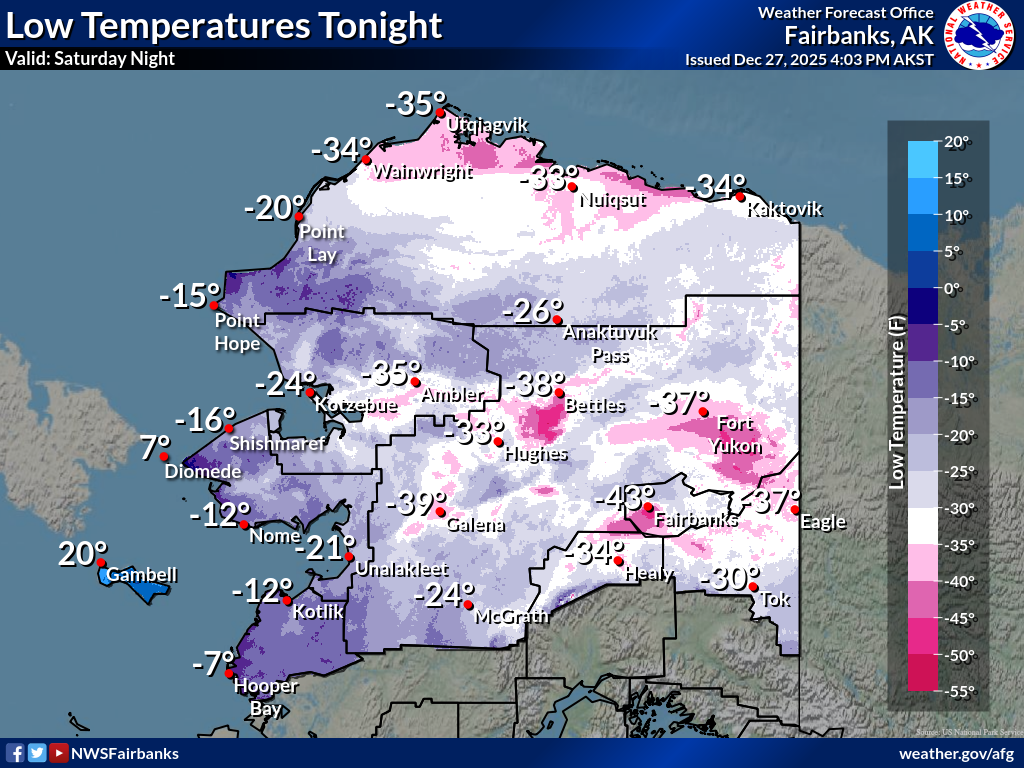
Dangerous wind chills and blowing snow continue across the Matanuska-Susitna Valley tonight as strong northerly winds funnel through the passes, creating slick roads, drifting snow and periods of reduced visibility (source: National Weather Service, https://www.weather.gov/afg?story=6).
By Gina Hill | Alaska Headline Living | December 2025
Issued Saturday Night, December 27, 2025Primary sources: NOAA and National Weather Service Alaska
By Gina Hill | Alaska Headline Living | December 2025
STARTING TONIGHT: MATANUSKA-SUSITNA VALLEY AT HIGH RISK
The National Weather Service warns that dangerous high winds and blowing snow will continue tonight through Sunday and into early next week across the Matanuska-Susitna Valley. Conditions are already deteriorating and will remain hazardous, especially overnight when visibility drops and wind chills worsen.
TONIGHT – SATURDAY NIGHT
Northeast winds will remain strong overnight, sustained at 20 to 30 mph with gusts frequently reaching 45 to 60 mphand locally higher in exposed areas. Light snow combined with these winds will cause blowing and drifting snow, sharply reducing visibility on roads and in open areas. Temperatures will fall into the single digits to low teens, with wind chills below zero. Travel may become dangerous quickly and unexpectedly.
SUNDAY – CONDITIONS REMAIN DANGEROUS
On Sunday, the Mat-Su will stay locked under the same pattern. Northeast winds continue at 25 to 35 mph with gusts up to 50 to 55 mph. Blowing snow remains likely even where new snowfall is light. Visibility will be reduced at times, particularly along the Glenn Highway, Parks Highway, and across open valley corridors. Cold air combined with wind will make outdoor exposure hazardous.
SUNDAY NIGHT INTO MONDAY
Winds stay elevated Sunday night, again producing blowing snow and dangerous wind chills. By Monday, winds may slowly ease but remain gusty enough to keep travel impacts ongoing. Snow chances increase slightly late Monday, which could worsen drifting and visibility issues.
WHY THIS STORM MATTERS FOR THE MAT-SU
The National Weather Service emphasizes that wind is the primary threat, not snowfall totals. Even small amounts of snow become dangerous when combined with strong northeast winds. Given recent storm damage in the Mat-Su, additional impacts may include power disruptions, downed branches, and debris hazards.
STATEWIDE CONTEXT
Across Alaska, NOAA reports multiple active alerts including High Wind Warnings, Winter Weather Advisories, Storm Warnings, Gale Warnings, and Heavy Freezing Spray Warnings, especially affecting coastal and marine zones. This reinforces that Alaska remains under a broad and intense winter pattern.
WHAT RESIDENTS SHOULD DO NOW
Secure loose outdoor items immediately.
Avoid unnecessary travel tonight and Sunday if possible.
Carry winter survival gear if travel is unavoidable.
Prepare for possible power outages.
Check road conditions before leaving and monitor official National Weather Service updates closely.
This is not a routine winter night for the Mat-Su Valley. The combination of wind, cold, and blowing snow makes tonight and Sunday especially dangerous. Stay weather aware and take this alert seriously.